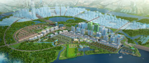
Thu Thiem New Urban Area is on the banks of the Saigon River, opposite District 1, planned to be a new, modern and expanded central area. This will provide full high-class functionalities, promise to be one Financial Center the “Wall Street”, Dynamic Entertainment Center Of Ho Chi Minh City.
Overview of Thu Thiem Urban Area
It is a big project in Thu Thiem peninsula, District 2 opposite District 1 across the Saigon River, now in Thu Duc City after its establishment. On June 19, 2012, the People’s Committee of Ho Chi Minh City issued Decision No. 3165 / QD-UBND approving the project of partial adjustment of zoning planning at the scale of 1/2000 new urban centers. Thu Thiem, planning to become a commercial and financial center with 10-40 storey high buildings, residential area meets 130,000 people and 1,000,000 visitors. This is a rich ecological area in the South with a system of dredged canals, ponds and lakes.
Scale of the Urban Area
Having an area of 657 hectares Thu Thiem including An Khanh, Thu Thiem, An Loi Dong and a part of Binh An, Binh Khanh which located strategically within the northeast growth ring of HCMC, the unique location, opposite District 1 from the Saigon River.

Total population of regular residents is 145,400 people, the number of regular employees is 219,200 people, of which visitors are 1,000,000 people (maximum during the festival), Office for rent apartment type is 1,700 people.
Reasons for HCMC Conducting Thu Thiem Planning
The peninsula in the old Thu Duc district is a lowland area with costly infrastructure construction and many risks such as landslides and land subsidence. In 1992, Ho Chi Minh City advocated planning Thu Thiem area to become an international financial and commercial center.
After preparing for more than 3 years, the project was approved by the city collective, including the People’s Committee of Ho Chi Minh City and the Ministry of Construction. Then Prime Minister Vo Van Kiet signed Decision No. 367 / TTG on June 4, 1996 approving the planning for construction of Thu Thiem new urban area.
On December 27, 2005, Vice Chairman of Ho Chi Minh City People’s Committee Nguyen Van Dua signed Decision 6565, replacing Decision 367 / TTG, adjusting the general planning for construction of Thu Thiem new urban center.
Map of Thu Thiem Urban Planning
There are 8 areas with different functions in Thu Thiem new urban center, private building density with public spaces and prominent works.

In addition, to connect Thu Thiem new urban area with districts in the city, the government has planned to build 5 bridges located in different areas: Thu Thiem 1, 2, 3, 4 and Thu Thiem pedestrian bridge.
At present, Thu Thiem No. 1 Bridge has been completed and put into use, Thu Thiem No. 2 Bridge is in the construction phase, Thu Thiem No. 3; No. 4 Bridges and Pedestrian Bridge awaiting the completion of the port relocation.
Thu Thiem Urban Area Planning Plan
Functional Area No. 1

Located in the northern half of the central core area, is a high-density multi-functional commercial and service center. This is the location of important public and prominent works such as:
- Exhibition convention center with pedestrian bridge over channel 1 connected to the Museum House;
- The Symphonic Theater which next to it is The Opera Residences of the Metropole Thu Thiem project
- Planning information center
Functional Area No. 2

A high-density complex with commercial, multi-functional residential and sports and entertainment functions located south of the central core. This functional area is divided into 3 subdivisions:
- Zone 2a is in the north east-west boulevard
- Zone 2b with the complex Observation Tower of Empire City project which will be marked as the Landmark of Thu Thiem area
- Zone 2c is the complex of Sports and Entertainment
Some prominent works: Observation tower complex, Stadium, multi-purpose gym, schools and local administrative center.
Functional Area No. 3

A mixed residential function area, located along the north bank of Thu Thiem with the highlight of the 5-star boutique project The River Thu Thiem inherits 100m of river and 4ha of park, including:
- Schools
- The museum opposite the exhibition convention center via channel 1
Functional Area No. 4

A mixed residential area located in the north of Thu Thiem. Important highlight works include:
- Three schools
- Community activities center
- Local administrative agencies
- Fire station and material supply station
Functional Area No. 5

Including public works on the East-West Avenue, residential area south of East-West Avenue and multi-function commercial buildings with key public works:
- Children’s cultural houses
- Urban Administration Building
- Fuel supply station
- Two schools
- Community activities center
- Local Administration
Functional Area No. 6

Located in the area along the east-west boulevard and between the canals. This area is arranged:
- Software park
- International Hospital
- Internal bus routes
- The metro line leads into the station area located at the Hospital and the software park
Functional Area No. 7

In the easternmost position of Thu Thiem with:
- Delta resort hotel area
- The marina complex
- Surrounded by commercial areas, restaurants, shops and motels
Functional Area No. 8

This is the southern submerged ecological area, considered an important conservation area of the Thu Thiem peninsula. There are 3 projects built in this area:
- Resort Hotel in the Southern Floating Delta (built on piles) located in the West
- Water park
- Plant research area
The Importance Of Thu Thiem Urban Area For Ho Chi Minh City
Thu Thiem new urban area is planned to be a new, modern and expanded center of Ho Chi Minh City with functions such as cultural, financial, commercial, and service center of the city. Thu Thiem new urban center is a strategic project, opening up opportunities to accelerate development in all aspects for Ho Chi Minh City, contributing to enhancing the city’s position in the world.

Source: Thuthiem


